WICCI climate scientists have “down-scaled” global climate models to project how Wisconsin’s climate has been changing and how it might change in the years to come. View the maps to see historical trends and future projections for temperatures and precipitation.
The studies of historical trends and future projections reveal an emerging consensus on the range of possible climate changes that Wisconsin will experience. In particular, these studies find that Wisconsin is likely to become a much warmer state over the next few decades, with average temperatures more like those currently experiences in states hundreds of miles to our south.
Our state is also likely to become somewhat wetter, with a modest increase in total precipitation and in the number of intense rainfall events. The amount of climate change varies by season, with winter experiencing the greatest warming and most likely increase in precipitation.
If you have questions about these maps, contact Dan Vimont of WICCI’s Climate Working Group at dvimont@wisc.edu.
Interactive Mapping Tool
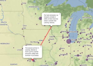
What will Wisconsin’s climate look like in the future? A map from the University of Maryland allows you to choose many locations in our state and see their climate analogs — places in the United States that currently resemble what Wisconsin’s climate is projected to be like in 2080.
Historical Trends (1950-2024)
These maps use county-level data from NOAA’s National Climatic Data Center (NCDC) nClimDiv dataset. You can view and download this data from NOAA’s Climate at a Glance – County Time series tool.
Future Projections (2041-2060)
These maps and charts refer to the middle 21st century, averaged over years 2041-2060, relative to the recent 30-year historical average from 1991 to 2020. They use data from the CMIP6 climate projections.